


Automatic Identification System (AIS). What is AIS Data?
The automatic identification system transmits the position of the vessel so that other vessels in the vicinity know its position. International organizations such as the IMO require large commercial vessels to use AIS for safety reasons and to avoid collisions with other vessels
The world of AIS (or Automatic Identification System) can often be confusing to delve into and many questions arise such as "what is AIS?" "Why do I need it?" and "What type of AIS does my ship need?"
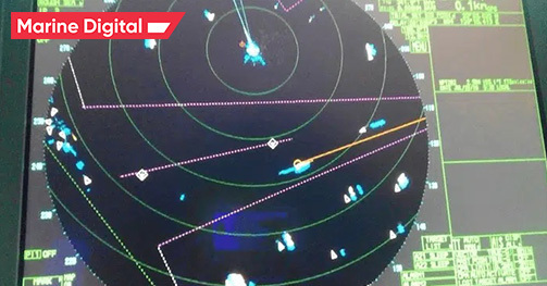
The Automatic Identification System (AIS) is an automated tracking system that displays other vessels in the vicinity. The transponder broadcasting system operates in the VHF range of maritime mobile communications.
Your ship is also displayed on the screens of other ships nearby if your ship is equipped with AIS. If AIS is not installed or enabled, there is no exchange of vessel information via AIS.
Simply put, the automatic identification system transmits the position of the vessel so that other vessels in the vicinity know its position. International organizations such as the IMO require large commercial vessels to use AIS for safety reasons and to avoid collisions with other vessels.
On-board AIS should always be on unless the captain decides that it needs to be turned off for safety or other reasons. AIS operation mode is continuous and autonomous.
It is installed on ships to identify ships and navigational signs. However, this is only a navigational aid and should not be used for collision avoidance. Coastal Vessel Traffic Services (VTS) use AIS to identify, locate, and monitorships. The Panama Canal uses AIS to provide information about rain along the canal and wind at the locks.
Why is AIS provided?
Regulation V/19.2.4 of the IMO Safety of Life at Sea (SOLAS) Convention requires that all ships of 300 gross tonnages and above engaged on international voyages and all passenger ships, regardless of size, carry AIS.
SOLAS Requirements
There are two AIS classes: A and B. The first is mandatory for all ships of 300 gross tonnages and above engaged in international voyages and all passenger ships. The latter has limited functionality and is designed for ships that do not comply with SOLAS requirements. Mainly used for pleasure craft.
It uses Self Organizing Time Division Multiple Access (STDMA) technology to provide high-speed broadcasting. This frequency limits the line-of-sight range, which is about 40 miles.
- Class A: Mandated for all vessels 300 GT and above engaged on international voyages as well as all passenger ships
- Class B: Provides limited functionality and is intended for non-SOLAS vessels. Primarily used for vessels such as pleasure crafts
- AIS 1: Works on 161.975 MHz- Channel 87B (Simplex, for the ship to ship)
- AIS 2: 162.025 MHz- Channel 88B (Duplex for the ship to shore)
It uses Self Organizing Time Division Multiple Access (STDMA) technology to provide high-speed broadcasting. This frequency limits the line-of-sight range, which is about 40 miles.
AIS Types
AIS works by determining the position and movements of the vessel using GPS or internal sensors built into the AIS unit. It is installed on ships to identify ships and navigational signs. However, this is only a navigational aid and should not be used for collision avoidance.
Initially, AIS was used on land, that is, the signal was sent from a boat to land and had a range of approximately 20 miles (also taking into account the curvature of the earth). As the ships moved away from the earth, they began to send a signal to low-orbit satellites, transmitting information back to earth. This meant that the ships could sail as far as they wanted, and we would always have peace of mind knowing exactly where they were and how they were doing.
The AIS system consists of one VHF transmitter, two VHF TDMA receivers, one VHF DSC receiver, and a standard maritime electronic link to onboard display and sensor systems. The location and time information usually comes from the built-in or external GPS receiver. Other information transmitted by AIS is received electronically from onboard equipment through standard marine data connections.
Although only one channel is needed, each station transmits and receives on two radio channels to avoid interference and loss of communication with ships. The position report from one AIS station corresponds to one of the 2250 time slots set every 60 seconds. AIS stations are constantly synchronized to avoid overlapping slot transmissions.
It's also fairly easy to install, as AIS usually integrates with a ship's bridge systems or multifunction displays, but installing a standalone system is as simple as plugging in a couple of cables and plugging in a plug.
How AIS Works
AIS data is divided into three categories: static data, which consists of information about the characteristics of the ship. The second is dynamic data, which is constantly changing due to the constant movement of ships, and the last is current data related to the voyage
1. Static Information (Every 6 minutes and on request):
4. Short safety-related messages
1. Static Information (Every 6 minutes and on request):
- MMSI number
- IMO number
- Name and Call Sign
- Length and Beam
- Type of ship
- Location of position fixing antenna
- Ship's position with accuracy indication
- Position timestamp (in UTC)
- Course Over Ground (COG)
- Ship's draught
- Type of cargo
- Destination and ETA
- Route plan (Waypoints)
4. Short safety-related messages
- A free-form text message addressed to one or more destinations, or to all stations in the area. This may be, for example, the absence of a buoy, the discovery of an iceberg, etc.
Data Transmitted
In coastal waters, coastal authorities may install automated AIS stations to monitor vessel traffic in the area.
Coast stations can also use AIS channels for shore-to-ship transmission and to send tide, NTM, and weather information.
Coast stations can use AIS to monitor the movement of dangerous goods and manage commercial fishing in their waters. AIS can also be used for search and rescue operations, allowing search and rescue authorities to use AIS information to assess the presence of other vessels in the vicinity of an accident.
AIS as a surveillance tool
AIS makes a significant contribution to the safety of navigation. All information transmitted and received increases the efficiency of navigation and can significantly improve situational awareness and decision-making.
As an officer in charge of the navigational watch, tracking and monitoring targets with AIS and determining CPA and TCPA information make a big contribution to the safety of navigation in general.
However, the user should not rely solely on AIS information for collision avoidance. AIS is only an additional source of information for the watch officer and only supports the ship's navigation process. AIS will never replace the human experience on bridges!
AIS as an aid to collision avoidance
As with all navigational and/or electronic equipment, the AIS has limitations:
Summing up, we can say that AIS improves the safety of navigation only through the assistance of the Officer of the Watch/VTS or some other organization. It's also pretty easy to install, as AIS usually integrates with a ship's bridge systems or multifunction displays, but installing a standalone system is as easy as plugging in a couple of cables and plugging in a plug.
For more information, Download the Guide to AIS the Complete Guide to AIS
- The accuracy of AIS information received is only as good as the accuracy of the AIS information transmitted
- The position received on the AIS display might not be referenced to the WGS 84 datum
- Over-reliance on the AIS can cause complacency on the part of the OOW
- Users must be aware that the AIS might transmit erroneous information from another ship
- Not all ships are fitted with AIS
- The officer in charge of the watch should be aware that AIS, if installed, can be disabled by a particular ship, thereby nullifying any information that may have been obtained from that ship.
- It would be unreasonable on the part of the officer in charge of the navigational watch to assume that the information received from other ships may not be entirely accurate and not as accurate as on his ship.
Summing up, we can say that AIS improves the safety of navigation only through the assistance of the Officer of the Watch/VTS or some other organization. It's also pretty easy to install, as AIS usually integrates with a ship's bridge systems or multifunction displays, but installing a standalone system is as easy as plugging in a couple of cables and plugging in a plug.
For more information, Download the Guide to AIS the Complete Guide to AIS
Limitations of AIS
MarineTraffic is the world's leading provider of ship tracking and maritime intelligence.
Monitoring vessel movements are at the core of what they do. Building on a base of data gathered from a network of coastal AIS-receiving stations, supplemented by satellite receivers, MarineTraffic applies algorithms and integrates complementary data sources to provide the shipping, trade, and logistics industries with actionable insights into shipping activity.
Monitoring vessel movements are at the core of what they do. Building on a base of data gathered from a network of coastal AIS-receiving stations, supplemented by satellite receivers, MarineTraffic applies algorithms and integrates complementary data sources to provide the shipping, trade, and logistics industries with actionable insights into shipping activity.

VesselFinder is dedicated to providing real-time data on the positions and movements of over 200,000 vessels every day, utilizing a large network of Terrestrial AIS receivers and Satellites all over the world. Increasing the range of offered services over the years, VesselFinder has evolved into an international digital brand and become the premier source of vessel tracking solutions and news covering the world maritime industry.

The Automatic Identification System (AIS) is an automatic tracking system used on ships for identifying and locating vessels to avoid collisions. Also, port authorities use AIS to better control sea traffic.
myShipTracking is a website that uses this technology in order to provide a better understanding of how vessels move around the world.
myShipTracking is a website that uses this technology in order to provide a better understanding of how vessels move around the world.
Established in 2007, FleetMon built the world's first public vessel data collection, which helps organisations deliver better logistic reports.
FleetMon empowers shipping companies, captains and maritime enthusiasts by allowing them to track and analyze their business.
FleetMon empowers shipping companies, captains and maritime enthusiasts by allowing them to track and analyze their business.

Spire build customized datasets using our unrivaled radio occultation technology to gather information from every point on Earth, combine them with trustworthy supplemental data sources, and enable data-driven decisions across the enterprise with easy-to-use APIs.

Algorithmic core of Marine Digital solution uses AIS for energy efficency analysis, restoring missing data and verifing the noon report parameters.
Marine Digital has huge experience in the automation of logistics processes and operations management in shipping.
The Voyage module of the Marine Digital Fuel Optimization System gives digital noon reports, performance analysis, and environmental reports based on AIS data.
The reporting module in the voyage optimization system facilitates:
Marine Digital solution works within the following frameworks of efficiency analysis:
For Marine Digital artificial intelligence solution it takes only 1 minute to analyze the historical routes of your fleet and give you a clear understanding of where you can save money and what caused the inefficiency.
Marine Digital has huge experience in the automation of logistics processes and operations management in shipping.
The Voyage module of the Marine Digital Fuel Optimization System gives digital noon reports, performance analysis, and environmental reports based on AIS data.
The reporting module in the voyage optimization system facilitates:
- Generation of digital noon reports
- Voyage planning taking into account the weather conditions
- Fuel optimization based on ETA, layman, and other operational factors
- Recommends RPM to achieve maximum power output and minimum GHG emissions
- Vessel fuel performance analysis, and reporting e.g. Energy Efficiency.
- Environmental reporting - all data needed and automatically calculated for IMO reporting
- Built-in Business Intelligence Dashboards track real-time voyages against estimated results based on data.
Marine Digital solution works within the following frameworks of efficiency analysis:
For Marine Digital artificial intelligence solution it takes only 1 minute to analyze the historical routes of your fleet and give you a clear understanding of where you can save money and what caused the inefficiency.


Get free test access with a description of the solution


TOP 5 factors contributing to lower fuel costs for Shipping companies
Get a presentation with a full description of the features and free pilot project with trial of Marine Digital FOS for 2 months
"Clicking the button, you consent to the processing of personal data and agree to the privacy policy"

Get an overview "The Pathway to Zero Carbon Shipping:
IMO Compliance and CII Optimization through SEEMP" on email and download it for FREE! Leave your email now!
"Clicking the button, you consent to the processing of personal data and agree to the privacy policy, as well as consent to subscribe to the newsletter. "
Аdvantage of Fuel Optimization System from Marine Digital:

Marine Digital FOS can be integrated with other system and third-party's solutions through the API. To implement vessel performance monitoring for any vessel, we are using mathematical algorithms, machine learning and the same equipment as in FOS. The more data we collect from vessels, the more precise reports and recommendations our system will perform according to your individual requirements in fleet management.
If you have any questions about the solutions and the Marine Digital System platform, write to us, we will be happy to answer
If you have any questions about the solutions and the Marine Digital System platform, write to us, we will be happy to answer

Increased business process speed

Reducing to zero the number of errors

Best offer to the clients

Reduction in operating expenses
Have a questions?
